


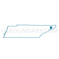
08-2 Cherokee Outside Voting District, Washington County, Tennessee
About
Outline

Summary
| Unique Area Identifier | 669912 |
| Name | 08-2 Cherokee Outside Voting District |
| County | Washington County |
| State | Tennessee |
| Area (square miles) | 14.55 |
| Land Area (square miles) | 14.55 |
| Water Area (square miles) | 0.00 |
| % of Land Area | 100.00 |
| % of Water Area | 0.00 |
| Latitude of the Internal Point | 36.25864590 |
| Longtitude of the Internal Point | -82.38697850 |
Maps


Graphs
Select a template below for downloading or customizing gragh for 08-2 Cherokee Outside Voting District, Washington County, Tennessee


Neighbors
Neighoring Voting District (by Name) Neighboring Voting District on the Map
- 04 Lamar School Voting District, Washington County, TN
- 08-1 Midway Outside Voting District, Washington County, TN
- 08-14 Cherokee Inside Voting District, Washington County, TN
- 08-15 Midway Inside Voting District, Washington County, TN
- 08-16 Fire Training Center Voting District, Washington County, TN
- 09-1 South Side School Voting District, Washington County, TN
- 09-8 Adelphia Centre Voting District, Washington County, TN
- 15-2 Jonesborough Courthouse Voting District, Washington County, TN
- Happy Valley Voting District, Carter County, TN
- Unicoi Voting District, Unicoi County, TN
Top 10 Neighboring County Subdivision (by Population) Neighboring County Subdivision on the Map
- District 6, Washington County, TN (16,428)
- District 4, Washington County, TN (13,937)
- District 5, Washington County, TN (13,168)
- District 5, Carter County, TN (7,363)
- District 3, Unicoi County, TN (6,873)
Top 10 Neighboring Place (by Population) Neighboring Place on the Map
Top 10 Neighboring Unified School District (by Population) Neighboring Unified School District on the Map
- Washington County School District, TN (63,291)
- Johnson City School District, TN (59,688)
- Carter County School District, TN (43,248)
- Unicoi County School District, TN (18,313)
Top 10 Neighboring State Legislative District Lower Chamber (by Population) Neighboring State Legislative District Lower Chamber on the Map
- State House District 7, TN (63,995)
- State House District 6, TN (63,258)
- State House District 5, TN (59,380)
- State House District 4, TN (57,424)
Top 10 Neighboring State Legislative District Upper Chamber (by Population) Neighboring State Legislative District Upper Chamber on the Map
Top 10 Neighboring 111th Congressional District (by Population) Neighboring 111th Congressional District on the Map
Top 10 Neighboring Census Tract (by Population) Neighboring Census Tract on the Map
- Census Tract 606, Washington County, TN (7,045)
- Census Tract 618, Washington County, TN (6,775)
- Census Tract 605.02, Washington County, TN (5,992)
- Census Tract 803, Unicoi County, TN (5,138)
- Census Tract 708, Carter County, TN (2,867)